Deception Island
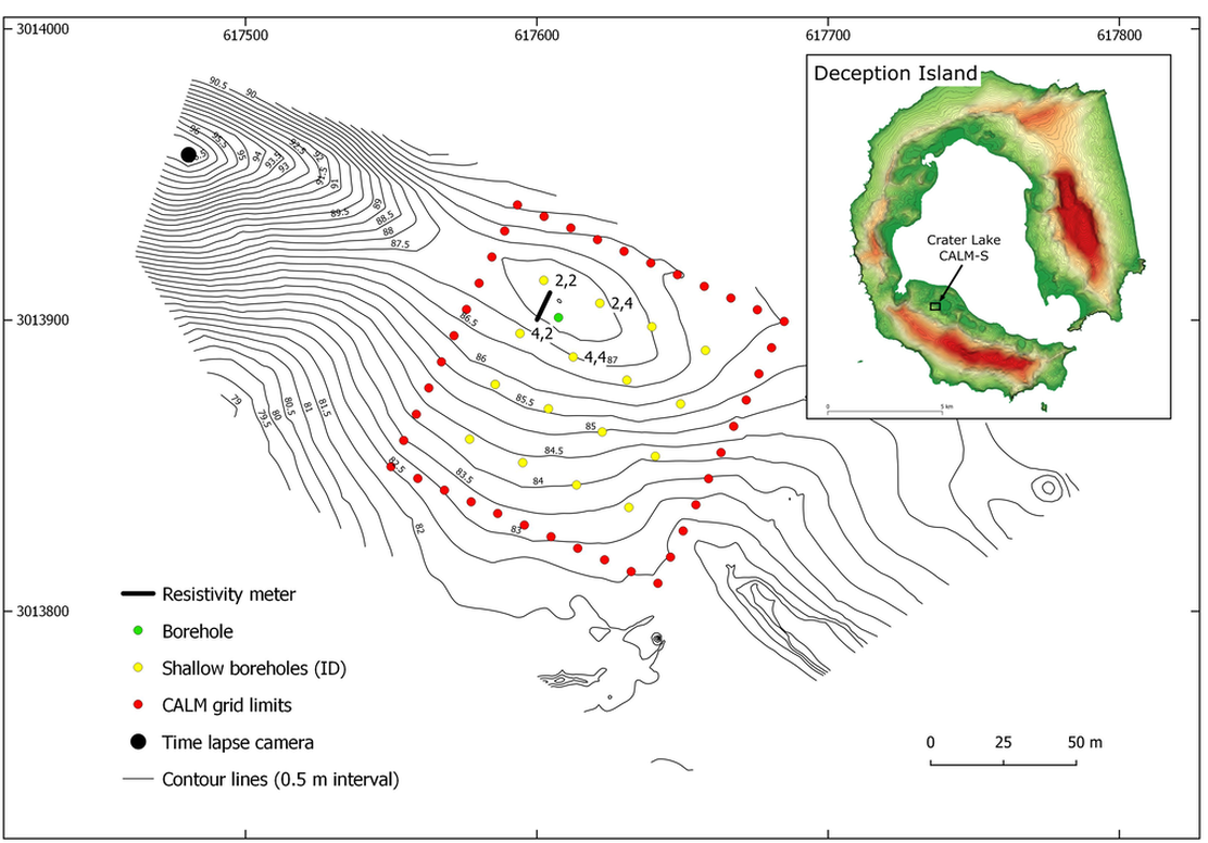
Deception Island (62° 55′ S, 60° 37′W) is located about 100 km north of the Antarctic Peninsula (AP), in the Bransfield Strait and is part of the South Shetlands archipelago. The Crater Lake CALM-S site is located in a small and relatively flat plateau-like surface covered by volcanic and pyroclastic deposits at 85 m a.s.l, north of Crater Lake (62°59′06.7″ S, 60°40′44.8″ W). The site was selected due to its flat characteristics, absent summer snow cover, large distance to known geothermal anomalies, good exposure to the regional climate conditions (mitigating site-specific effects and being representative in a regional context) and because of the vicinity to the Spanish station Gabriel de Castilla. The site includes monitoring of air temperature, permafrost and the active layer in boreholes, and snow thickness.
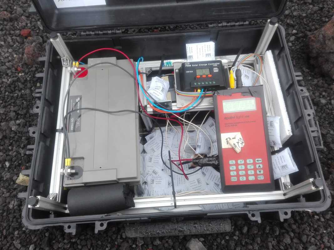
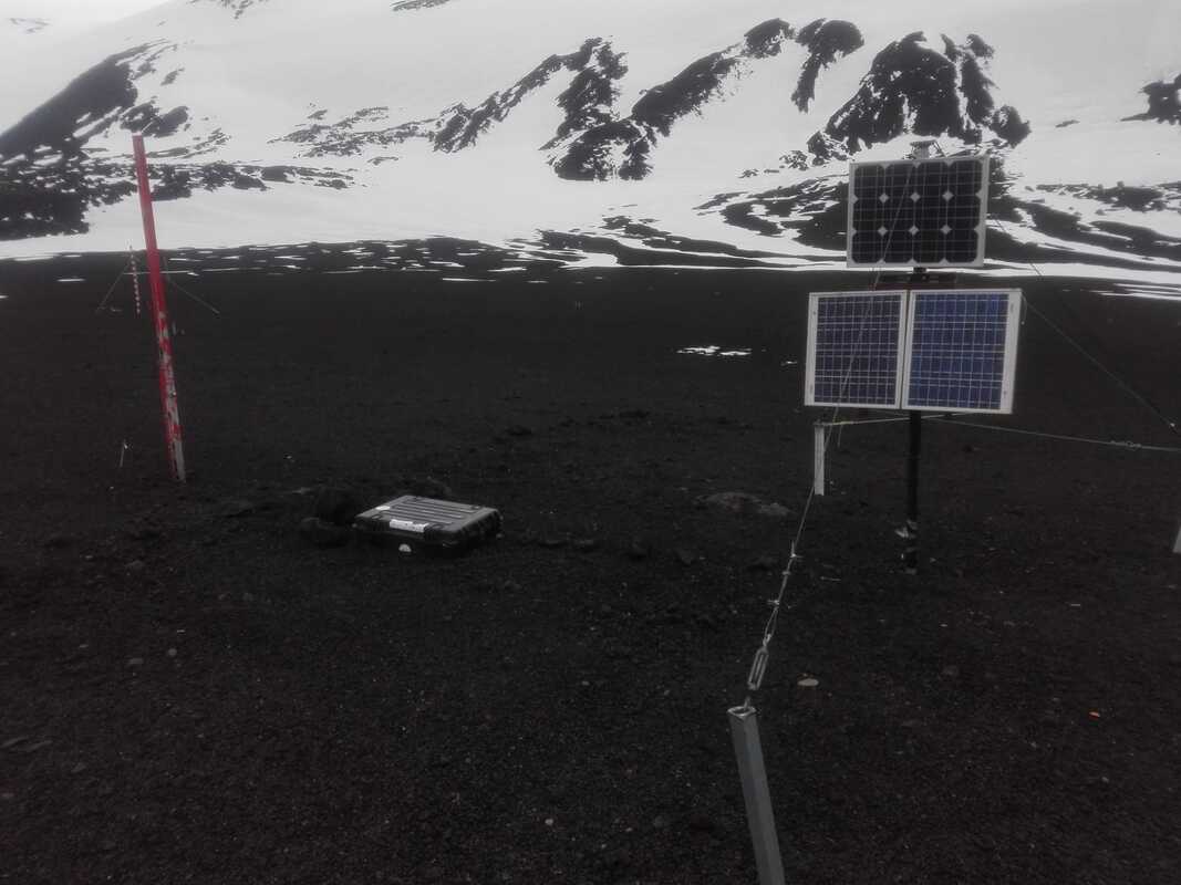
An automatic ERT (A-ERT) monitoring system using a 4POINTLIGHT_10W (Lippmann) instrument, was installed in the vicinity of the ground temperature borehole in order to monitor active layer freezing and thawing by ground surface time-lapse surveys. The Lippmann resistivity meter was programmed in combination with multi-electrodes for ERT surveys and measurements were performed using the Wenner electrode configuration to minimize energy consumption and measurement time as well as to obtain the best signal-to-noise ratio in highly resistive terrain. we used 20 copper plates for a better ground contact, with an electrode spacing of 0.5 m and measurements were repeated in 6h intervals since January 2019. A robust, water-proof box (explorer cases 5833B was used and buried, casing the 4POINTLIGHT_10W instrument, solar panel-driven battery and multi-electrodes connectors during data acquisition. This setup yields 56 individual data points for each monitoring data set at six data levels.
Deception Island (62° 55′ S, 60° 37′W) is located about 100 km north of the Antarctic Peninsula (AP), in the Bransfield Strait and is part of the South Shetlands archipelago. The Crater Lake CALM-S site is located in a small and relatively flat plateau-like surface covered by volcanic and pyroclastic deposits at 85 m a.s.l, north of Crater Lake (62°59′06.7″ S, 60°40′44.8″ W). The site was selected due to its flat characteristics, absent summer snow cover, large distance to known geothermal anomalies, good exposure to the regional climate conditions (mitigating site-specific effects and being representative in a regional context) and because of the vicinity to the Spanish station Gabriel de Castilla. The site includes monitoring of air temperature, permafrost and the active layer in boreholes, and snow thickness.
An automatic ERT (A-ERT) monitoring system using a 4POINTLIGHT_10W (Lippmann) instrument, was installed in the vicinity of the ground temperature borehole in order to monitor active layer freezing and thawing by ground surface time-lapse surveys. The Lippmann resistivity meter was programmed in combination with multi-electrodes for ERT surveys and measurements were performed using the Wenner electrode configuration to minimize energy consumption and measurement time as well as to obtain the best signal-to-noise ratio in highly resistive terrain. we used 20 copper plates for a better ground contact, with an electrode spacing of 0.5 m and measurements were repeated in 6h intervals since January 2019. A robust, water-proof box (explorer cases 5833B was used and buried, casing the 4POINTLIGHT_10W instrument, solar panel-driven battery and multi-electrodes connectors during data acquisition. This setup yields 56 individual data points for each monitoring data set at six data levels.